The current conditions map allows users view current and on-going events occurring on roadways in the New York/New Jersey/Connecticut metropolitan area. The map is fully interactive and allows panning, zooming to view a particular area or region as well the ability to select different base maps and transportation-related events to view.
Figure 1 - Map Widget
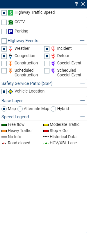
To allow users the flexibility to view only those events/activities of interest to them, various icons are located on the upper right portion of the map that are filtered by specific criteria: Traffic speed layer, weather-related events, incidents, congestion, construction, detour, special events, camera and view full screen. All of the icons can be toggled on and off.
Different regions of New Jersey can be highlighted on the map, just by clicking on North, Central and South, available on the upper right portion of the map.
Map Icons
Figure 2 - Map icons
Full Screen View
Useto toggle full screen andto exit full screen.
Figure 3 - Full Screen View
Use the + or - to see a particular location in more detail or to observe a more regional view use the map zoom function. By selecting the + button, the map will zoom in to provide a more granular perspective on a specific location. Conversely, by selecting the � button, a more generic and broader scale view of roadway conditions will be provided.
Base Layers
To view the different base maps available, toggle the various map layers or to view the speed legend, simply click onThe following is presented:
Figure 4 - Map layers
Base layer section is option to change base map. User can click on any map view radio button to display selected base layer on map.
After the user has made a base map selection, please just click onicon to hide this menu box from screen.
Highway Events Layer
To view the different Highway Event layers available or toggle the various Highway Events, simply click on. The following is presented:
Figure 5 - Highway Events
By default, the Weather, Incident, Congestion and Detour Layers are displayed. Click on Construction option box to view that layer.
In the same way, a user can click on Special Events, Scheduled Construction or Scheduled Special Event check boxes to display the selected layers.
Event popup
Click on any event icon on the map, and it will show a pop-up with detailed information. Click to zoom to the exact location of the incident. For instance, click on Congestion icon, the following is presented:
Figure 6 - Event Pop-up
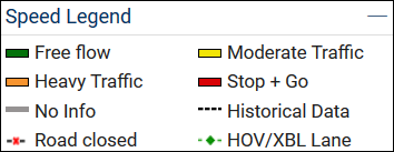
Speed Legend
Figure 7 - Speed Legend
The Speed Legend shown in the map menu provides users with a general overview of the current travel conditions along selected roadways. Color bands along the roadways delineate the status of the current roadway conditions. Each color denotes a varying level of congestion. The table below presents the defined congestion levels displayed in the Congestion Legend where the speed ranges are calculated as a percentage of the speed limit for each roadway segment. The "No Data" congestion level is used to indicate roadways for which there is no information currently available that would allow a congestion level to be determined.
Congestion Level
% of Speed Limit
Speeds based on a speed limit of
Default Color
25mph
35mph
45mph
55mph
65mph
Stop and Go
0-31
0-7
0-11
0-14
0-17
0-20
Red
Heavy Traffic
32-61
8-15
12-22
15-28
18-34
21-40
Orange
Moderate Traffic
62-91
16-23
23-32
29-41
35-50
41-60
Yellow
Free Flow
92-100(+)
24-25
33-35
42-45
51-55
61-65
Green
Data not available
N/A
N/A
N/A
N/A
N/A
N/A
Grey
Parking Information
Parking lot information generated by the Port Authority of NY & NJ for Newark, LaGuardia and JFK International Airports is available for viewing on the Current Status map. When a user selects thelayer icon on the map the individual parking lot occupancy status is provided for each airport and with an interactive bubble providing current lot information. The bubble is color coded to identify those lots which are either approaching or are at full capacity via a Red bubble and a lot with availability being presented with a Green bubble. If a user clicks on specific parking lot button, detailed lot information about the occupancy percentage will be provided.
Current status information is updated every 1-2 minutes for Congestion and Event information. All airport parking lot information is updated every 5 minutes.
In order to minimize the amount of repetitive actions required by users to view commonly requested information, this webpage uses cookies. Cookies are a small amount of data sent to your browser from a web server and stored on your computer's hard drive. This page uses both session cookies and persistent cookies. Session cookies expire after the user exits the website, or shortly thereafter, and are not generally considered to be a privacy or security concern. Persistent cookies tend to have a longer life-span and are used to retain user session information such as settings and configuration parameters. Cookies are unique to each website and information in them cannot be accessed by other websites. The cookies utilized do not provide any personal information about the user.
CCTV Information
Figure 8 - CCTV
Traffic Cameras are one the most requested features of the 511NJ website. The CCTV layer
allows users to view images, or, plays video streams from the New Jersey Department of Transportation and the New Jersey Turnpike Authority's traffic cameras. Simply select a camera icon from the map and click on it. It will play the most recent camera image in the camera window.
Safety Service Patrol(SSP)
Figure 9 - Safety Service Patrol(SSP)
The New Jersey Department of Transportation (NJDOT) provides a Safety Service Patrol (SSP) to assist motorists in need on certain State highways. Assistance includes changing flat tires, pushing a disabled vehicle off to the shoulder, pulling a vehicle trapped in the mud or snow back onto the road, providing a small amount of gasoline and making minor repairs. This has been a very successful program that started in 1994. The SSP drivers not only assist regular motorists but this program also assists the New Jersey State Police (NJSP) and other secondary responders by promoting safety and diverting traffic during incidents, which creates a safe work zone for emergency responders. New Jersey is committed to providing safety in all of its transportation related areas.
allows users to view current position of Safety Service Patrol vehicle.
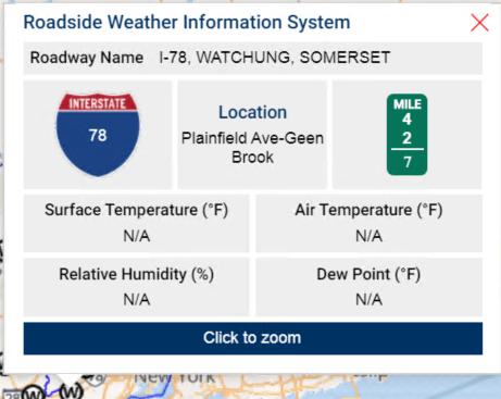
Weather Station
Figure 10 - Weather Station
Weather Station NJDOT. provides weather station information. station location, roadway, mile post
allows users to view station on map and information on click icon.


 to toggle full screen and
 to exit full screen.
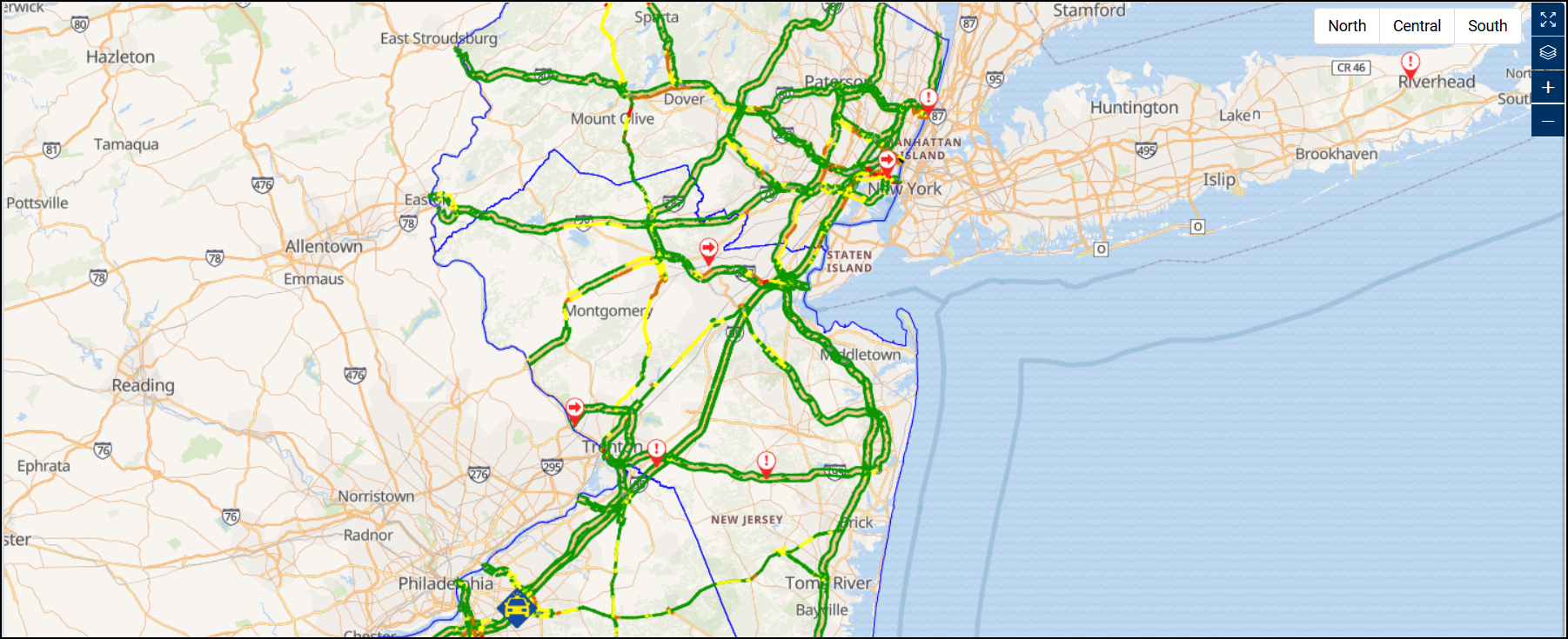
 Use the + or - to see a particular location in more detail or to observe a more regional view use the map zoom function. By selecting the + button, the map will zoom in to provide a more granular perspective on a specific location. Conversely, by selecting the � button, a more generic and broader scale view of roadway conditions will be provided.
 The following is presented:
 . The following is presented:

 layer icon on the map the individual parking lot occupancy status is provided for each airport and with an interactive bubble providing current lot information. The bubble is color coded to identify those lots which are either approaching or are at full capacity via a
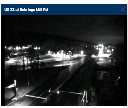
 allows users to view images, or, plays video streams from the New Jersey Department of Transportation and the New Jersey Turnpike Authority's traffic cameras. Simply select a camera icon from the map and click on it. It will play the most recent camera image in the camera window.

 allows users to view current position of Safety Service Patrol vehicle.